Administrative-Territorial Organisation of the States in the Caucasus Region in the 20th Century and the Beginning of the 21st Century
DOI:
https://doi.org/10.52340/ggj.2025.05.01.09Keywords:
North Caucasus, Central, Caucasus, South Caucasus, Region, ProvinceAbstract
Eurasia comprises numerous self-sufficient and, in many ways, important regions. One of the most polyethnic, polyconfessional and, as a result, culturally varied Caucasus, on the border of Europe and Asia, is one such place. The region is divided into two political-geographic parts: “North Caucasus” and “South Caucasus”. These terms represent the modern geopolitical transformation of the Russian terms "кавказ" and "закавказье," which were formed in the 19th century. It is important that these two terms did not occupy the whole area of the Caucasus and separate about ¼ part of the territory from the region; according to modern political geography, this land is part of the Middle East. Though, according to the various physical-geographic, historical-geographic and ethno-geographic sources, this land is part of the Caucasus. Eldar Ismailov, an Azerbaijani scientist, and Vladimer Papava, a Georgian scientist, defined the Caucasus region and developed a theory that divides it into three parts. The determination of the internal political-geographic structure during the close past and the modern time is the main goal of this article.
Downloads
References
Administrative Division. (2018). In N. Bolashvili, A. Dittmann, L. King, & V. Neidze, National Atlas of Georgia (pp. 8-9). Franz Steiner Verlag.
Administrative map of Caucasus in USSR, 1952-1991. (2024, October 1). Retrieved from www.armenica.org: https://www.armenica.org/cgi-bin/armenica.cgi?=1=3==Armenia
Administrative map of Elisabethpol Governorate - 1913. (1913). In Russia. Geographical description of the Russian Empire by provinces and regions with geographical maps (p. 75). Saint Petersburg: Typography.
Administrative map of Kars Oblast. (1913). In Russia. Geographical Description of the Russian Empire by Provinces and Regions with Geographical Maps (p. 76). Saint Petersburg: Thrift Pablishing.
Administrative-territorial organization of the Georgian SSR in 1981. (1981). In Georgian Soviet Encyclopedia, Volume 2. Tbilisi: Printed Word Combine.
Ana Vatan : [Turkey], 1927. (2024, October 01). Retrieved from loc.gov: https://www.loc.gov/resource/g7431f.ct003172/?r=0.146,-0.119,0.991,0.614,0
Armenian Delegation on Paris Peace Conference, 1919. (2024, October 01). Retrieved from gallica.bnf.fr: https://gallica.bnf.fr/ark:/12148/bpt6k34140447/f39
Caucasus. (2018). In N. Bolashvili, A. Dittmann, L. King, & V. Neidze, National Atlas of Georgia (pp. 4-5). Franz Steiner Verlag.
Cuinet, V. (1890). Erzurum Vilayet. In V. Cuinet, La Turquie d'Asie. Geographie administrative, statistique, descriptive et raisonné e de chaque province de l'Asie-Mineure. British Library HMNTS 10077.k.18.
Cuinet, V. (1890). Vilayet of Trebizond. In V. Cuinet, La Turquie d'Asie. Geographie administrative, statistique, descriptive et raisonné e de chaque province de l'Asie-Mineure. British Library HMNTS 10077.k.18.
Economic Regions of Azerbaijan. (2024, 10 01). Retrieved from mapr.com: https://www.mappr.co/counties/azerbaijan/
Erivan province. (1913). In Russia. Geographical Description of the Russian Empire by Provinces and Regions with Geographical Maps (pp. 80-81). Saint Petersburg: Thrift Pablishing.
Ethnographic map of the Baku Governorate. (1901). In Caucasian calendar for 1902: [57th year]. Commander-in-Chief of the Caucasian Part in the Caucasus.
Gachechiladze, R. (2023). Georgia in the Regional Context. Tbilisi: Bakur Sulakauri Publishing.
Georgia at the end of 19th century. (2012). In R. Gobejishvili, National Atlas of Georgia (p. 161). Tbilisi.
Georgian SSR, 1944 - 1955. (1954). In M. D. USSR, Atlas of the USSR. Moscow.
Goishvili, B., & Chkheidze, V. (2001). Geography of Georgia’s Bordering Area. Tbilisi: Ganatleba.
Hille, C. M. (2010). State Building and Conflict Resolution in the Caucasus. BRILL.
Ismaylov, E., & Papava, V. (2007). Central Caucasus: Outlines of the Geopolitical Economy. Tbilisi: Diogene.
Kazemzadeh, F. (2016). Battle for the South Caucasus 1917-1921. Tbilisi: Poezia.
Kuban Region. (1913). In Russia. Geographical description of the Russian Empire by provinces and regions with geographical maps (p. 70). Saint Petersburg: Thrift Pablishing.
Map of Dagestan Region. (1913). In Russia. Geographical description of the Russian Empire by provinces and regions with geographical maps (p. 74). Saint Petersburg: Thrift Pablishing.
Map of the Azerbaijan SSR. (1928). In A. S. Enukidze, Atlas of the Union of Soviet Socialist Republics (pp. 89-90). Moscow: Central Executive Committee of the USSR.
Map of the Black Sea Province. (1913). In Russia. Geographical description of the Russian Empire by provinces and regions with geographical maps (p. 79). Saint Petersburg: Thrift Pablishing.
Map of the Terek Region. (1913). In Russia. Geographical description of the Russian Empire by provinces and regions with geographical maps (p. 71). Saint Petersburg: Thrift Pablishing.
Metreveli, R. (2023). The History of Caucasus – part 1. Tbilisi: Artanuji.
Metreveli, R. (2023). The History of Caucasus – part 2. Tbilisi: Artanuji.
Persia. (1920). In Asprey's Atlas of the World (p. 82). London: Asprey and Co., Ltd.
Provinces of Armenia. (2024, 10 01). Retrieved from Mappr.com: https://www.mappr.co/counties/armenia/
Radvanyi, J., & Beruchashvili, N. (2009). Geopolitical Atlas of the Caucasus. Tbilisi: Bakur Sulakauri Publishing.
Sanadze, M., Beradze, T., & Thopuria, K. (2009). Georgia’s Historical Atlas. Tbilisi: Saqartvelos Matsne.
Soviet Armenia. (2024, October 01). Retrieved from armenica.org: https://www.armenica.org/cgi-bin/armenica.cgi?=1=3==Armenia
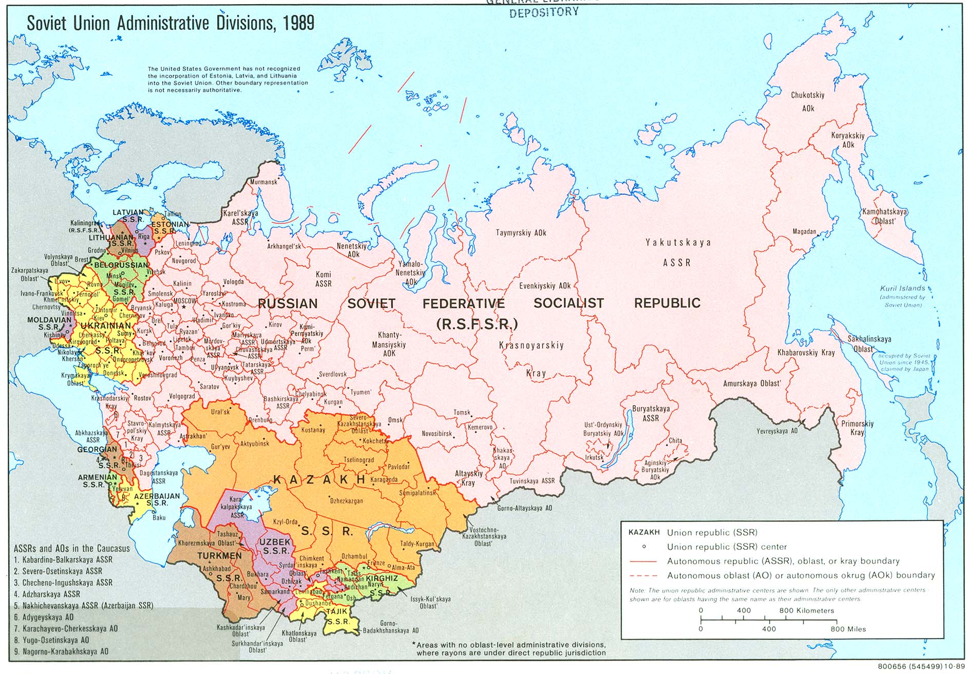
Soviet Union Administrative Divisions, 1989. (2024, 10 01). Retrieved from maps.lib.utexas.edu: https://maps.lib.utexas.edu/maps/commonwealth/soviet_union_admin_1989.jpg
Statistic Organization of Türkiye. (2024, October 01). the Census of the Population in 1927. Retrieved from teyit.org: https://cdn.teyit.org/wp-content/uploads/2019/11/nufustahriri.pdf
Statistic Organization of Türkiye. (2024, October 01). the Census of the Population in 1935. Retrieved from kutuphane.tuik.gov.tr: https://kutuphane.tuik.gov.tr/pdf/0015557.pdf
Stavropol Governorate. (1913). In Russia. Geographical Description of the Russian Empire by Provinces and Regions with Geographical Maps (pp. 69-70). Saint Petersburg: Thrift Pablishing.
The Map of the Territories Demanded by Georgia in 1920. (2024, October 01). Retrieved from archive.gov.ge: https://archive.gov.ge/ge/sakartelos-pirveli-demokratiuli-respublika
Walker, E. W. (2024, October 1). Eurasian Geopolitics. Retrieved from eurasiangeopolitics.com: https://eurasiangeopolitics.com/north-caucasus-maps/

Downloads
Published
How to Cite
Issue
Section
License
Copyright (c) 2025 Georgian Geographical Journal

This work is licensed under a Creative Commons Attribution 4.0 International License.
This work is licensed under a CC BY Attribution